Map of the United States : with the contiguous british &...


 Maps, plans and nautical charts
Map of the United States : with the contiguous british & spanish possessions (1819)
Maps, plans and nautical charts
Map of the United States : with the contiguous british & spanish possessions (1819)
 Disponible Holdings
 Section: Maps, plans and nautical charts
Uniform title: Estados Unidos. Mapas generales (1819). 1:3900000
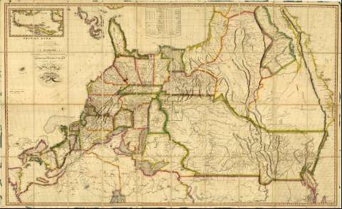
Title: Map of the United States : with the contiguous british & spanish possessions / Compiled from the latest & best Authorities by John Melish ; Engraved by J. Vallance & H.S. Tanner
Edición: Improved to the 1st. of April 1819
Material or type of resouce Area: Escala [ca. 1:3900000 ; proyección Sinusoidal de Sanson]
Publication: Philadelphia : Published by John Melish, 1819
Physical description: 1 mapa : col., montado sobre tela ; 89 x 145 cm
Content type: Imagen cartográfica
Media type: computadora
Carrier type: recurso en línea
Notes: Comprende desde la ciudad mexicana de Mazatlan hasta el extremo meridional de la Bahía de Hudson, destacándose la división entre los estados por líneas de diferente color
Fecha de la edición anterior: 6 de Junio de 1816
Escala gráfica de 150 millas [= 6'3 cm] y nominal de 60 millas por pulgada. Coordenadas referidas al meridiano de Londres (O 134°--O 53°/N 53° --N 23°) y Washington (O 57°--E 24°/N 53°--N 23°). Red geográfica de 1° en 1°
Orografía por perfiles
Indica la dirección y velocidad de las corrientes marinas en el Golfo
Tabla con datos sobre la superficie y población de cada uno de los estadosde Estados Unidos, así como de las posesiones británicas y españolas
Inserta: "West Indies".- Escala [ca. 1:15300000]
Materia / lugar / evento: Mapas generales
Divisiones administrativas
Colonias
1819
Caribe (Mar)
México
Other authors: Melish, John, 1771-1822
Vallance, J
Tanner, Henry Schenck, 1786-1858
UDC: (73)
Type of publication:
Maps
Rights:
Préstamo:
Disponible
